By Pepper Fisher
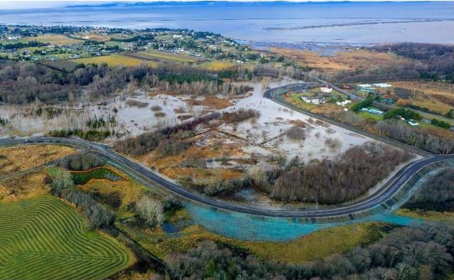
SEQUIM – What should be done with the half-mile section of Towne Road that has been rerouted atop the new levee at the floodplains of the Dungeness River near Sequim?
The original plan was to pave another two-lane road, connecting it once again to Anderson Road. But in September, residents were asked to participate in a survey that asked which of four alternatives they would like to see done with the top of the levee. The survey said that once the levee was completed, it had become a popular trail, and many people were petitioning county commissioners to keep it that way. The four alternatives are:
- Option 1: Construct a two-lane road to connect existing Towne Road to E. Anderson Road.
- Option 2: Construct a two-lane road and a separate six-foot trail surface.
- Option 3: Construct a one-lane, 16-foot road surface going south-bound only and a 12-foot-wide pedestrian trail-surface.
- Option 4: Construct a pedestrian trail only.
The new proposals didn’t sit right with many of the residents affected by the loss of that section of road, and they packed the Old Dungeness Schoolhouse to capacity Monday evening where they listened to a summary of events that contributed to the Towne Road closure and were asked to take steps to support its reopening. Local resident Jeff Tozzer was one of the organizers of the event. We asked what the primary concerns are for those who attended.
“Emergency service response times, fire, medics, police, to the northern communities. And also, a tsunami evacuation route for those looking to flee southward if a tsunami, or if the Dungeness River flooded, or any type of hazard were to happen. People are looking for a way out of their neighborhood”
The public comment period closed on October 10. Director of Community Development Bruce Emery and his team went over all of the data, and have submitted the following comments and recommendations to the commissioners, according to an email we received from Emery Wednesday afternoon.
“In considering each of the four alternatives, Alternative 4 received the most exclusive support at 45%. However, when considering the responses from the standpoint of a two-lane paved alternative (Alts 1 & 2) compared to a recreation-centered alternative (Alts 3 & 4), the results were close to an even split, with 49% of respondents favoring a recreational-centered alternative, and 51% favoring a two-lane road alternative. Divided between an exclusive recreational alternative and some form of through-road paved alternative, the divide is even greater, with 45% favoring a recreation-only alternative and 55% favoring some form of paved through-road alternative.
In considering these factors and the public sentiment expressed, it is the Department of Community Development’s recommendation that the Board of County Commissioners pursue the design features described in Alternative 2, with emphasis on utilizing surface expanding techniques to improve vehicle and recreational use, proportionately. Specifically, the minimum design parameters should include: two, ten-foot vehicle lanes with two-foot shoulders, guardrails, and a separate eight-foot-wide recreational-use path.”
Emery said an engineering consultant suggested a technique using geofabric wraps to extend the pedestrian surface. The technique could allow for an additional four feet of usable surface width on the levee, and make room for his office’s recommendation. The cost for the project is estimated at $3.75 million.
This is apparently what the commissioners will consider at their work session on December 5.